Mike Governale
Long before the rise of Midtown Plaza, or the Inner Loop, or the suburban two-car garage, electric trolleys carried Rochester residents from here to there, below the sidewalks.
But by June 30, 1956, the Rochester Subway was dead—if not yet buried.
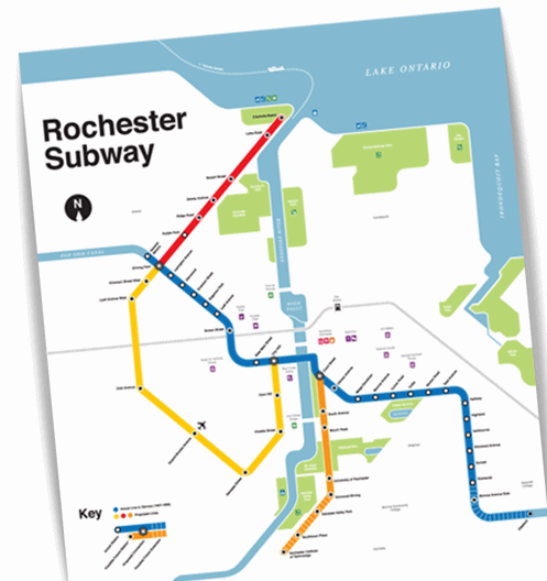 Mike created this modern-day Rochester Subway map with fellow RIT alum Otto Vondrak, who helped him identify all the old routes—the actual and proposed ones that never got built. Vondrack also wrote an inscription that appears at the bottom of the piece.Nearly forty years later, Mike moved here from Long Island to study illustration at RIT. He began digging into Rochester's past, stumbled upon the story of a dark subterranean corridor, and fell in love.
“Who'd have guessed that this sleepy town of a few hundred thousand people would have had electric trolley cars rumbling beneath its streets? Amazing!” he says.
As a graphic designer, he imagined what Rochester's subway system might look like today—and set out to create a map.
“Thought maybe I'd apply some Vignelli-esque style to it,” he says, referring to the designer of the iconic New York City Subway signage (and namesake of the Vignelli Center for Design Studies at RIT).
When he was done, Mike never expected anyone to take an interest in his pet project.
“The map hung quietly on my living room wall and I figured that's where it would stay, collecting dust,” he says.
 MikeUntil he put his first house up for sale.
“My real estate agent told me that everyone who walked through the house was more interested in where I got that great Rochester Subway map than in the house itself,” he says.
Mike, who now lives in the Rochester suburb of Irondequoit, decided to launch RochesterSubway.com and sell copies of the map. As the website gained traffic, he started blogging about Rochester's history—and future.
Developing a passion for the region has inspired him to get out there and get involved.
“Last year I wrote about a couple of people on Rochester's north side who are buying and fixing up abandoned homes near Clifford Avenue entirely with their own free time and money,” Mike says. “It's a fantastic story.”
 It's hard to imagine that these tracks once carried shoppers and commuters across town. Until 1956, they did. Photo by James Bogue, All Rights Reserved.He also recently started a transit advocacy group, Reconnect Rochester, to educate locals about the importance of a robust public transit system.
“The overwhelming majority of people who live and work in the Rochester region either don't have access to quality public transit, or if they do, they don't utilize it,” he says.
As you might guess, Mike considers public transit central to civic progress.
“Sustainability, economic development, equal access to jobs and services—even our national security—are all tied to the success of our public transit systems.”
There may never be another Rochester Subway.
But Mike's What-Might-Have-Been map could well be the first stop—on a way forward.

See more: RochesterSubway.com
Say hi: info@rochestersubway.com and on Facebook
Below: graffiti fills the passageway where the subway once passed through a former Erie Canal aqueduct. Photo by Chris Luckhardt, Some Rights Reserved.
